The essential elements of an orienteering map
(Adapted from ISOM 2017-2 with modifications and additions – refer to the standard for full details)
The development of orienteering maps reflects the needs of the sport and the technology available to produce them.
- The map should have a title that has relevance to the area.
- Map scale should be shown on the map. The base standard scale for an orienteering map is 1:15,000.
- Contour interval should be stated. The standard interval is 5 m. (In flat terrain 2.5 m contours may be used.)
- The map should have a magnetic north arrow.
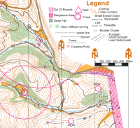
- A legend, setting out details of the symbols used on the map, is desirable.
- For safety reasons the map should have an emergency phone number and a gps reference point.
- A citation should be included setting out the data sources, currency (date of last revision). It may include access information, details of the organising club and its mapping team.
Legibility
Map legibility is the most important aspect of an orienteering map. In the process of producing a readable map, generalisation is the keyword. This means that the mapper must always deal with selection, simplification, displacement and exaggeration.
Generalisation
Skilful generalisation is necessary to ensure that maps are readable and suitable for orienteering competitions. The mapper must always consider that the orienteering map is read whilst running fast through the terrain, and that the perceptive capabilities of the human eye and brain have their limits.
Legible and Accurate
From the competitors’ point of view, a legible and accurate map is necessary for a qualified choice of route, and it enables them to navigate along the route chosen to suit their navigational skills and physical abilities. However, skill in route choice and map reading loses all meaning if the map is not a good representation of the ground - if it is of poor legibility, inaccurate or out-of-date. In the ideal case no competitor should gain an advantage or suffer a disadvantage because of faults on the map. For any event the ideal map should be up-to-date in all parts which could affect the result of the competition.
The steepness, elevation and shape of the landforms are essential information and are shown using contours. Identifying anything which impedes progress is crucial to the orienteer: e.g. cliffs, water, dense vegetation. The path and track network shows where the going and navigation is easiest. A detailed classification of the impediments to running and the ease of going helps the competitor to make the right decisions.
The aim of the course planner is a course where the deciding factor in the results will be navigational skill. This can be achieved only if the map is clear and legible under competition conditions and sufficiently accurate, complete and reliable. Controls are important building blocks of a course. Choice of sites, placing of the markers, checking their positions, and locating controls in competition, all put definite demands on the map. The better the map the course planners have, the greater chance they have of setting good, fair courses, whether for the elite orienteer or for the novice.
For the mapper, the task is knowing which features to map and how to represent them. A continuing involvement in the sport is important for a basic understanding of the requirements for the orienteering map: its content, the need for accuracy, the level of detail, and above all, the need for legibility.
Content desirables
The map shall contain sufficient information for the competing orienteer, while at the same time being legible at running speed and under varying weather and light conditions. This is accomplished by using a carefully designed set of symbols and colours and by emphasising generalisation.
The map shall only contain features which are obvious on the ground to a competitor at speed. It should show things which could influence map reading or route choice: landforms, rock features, ground surface, hindrance to progress through the vegetation (runnability), main land usage, hydrography, settlements and individual buildings, the path and track network, other lines of communication and features useful from the point of view of navigation. However, the most important thing is to maintain the clarity and legibility of the map through skilful generalisation.
The shape of the ground is the most important aspect of an orienteering map. The correct use of contours (including index contours) to show a three dimensional picture of the ground shape and height difference cannot be over emphasised.
The map must contain magnetic north lines that shall be parallel to the sides of the map. It may additionally contain some place names and peripheral text to help the competitor orientate the map to north. Such text shall be orientated to north. Text within the map shall be placed to avoid obscuring important features and the style of lettering should be simple. Arrowheads may be used to show magnetic north.
▲
Return to "A Resource for Mappers" Home Page